Inspecting 1000 KM of power lines for a Portuguese DSO in 30 days

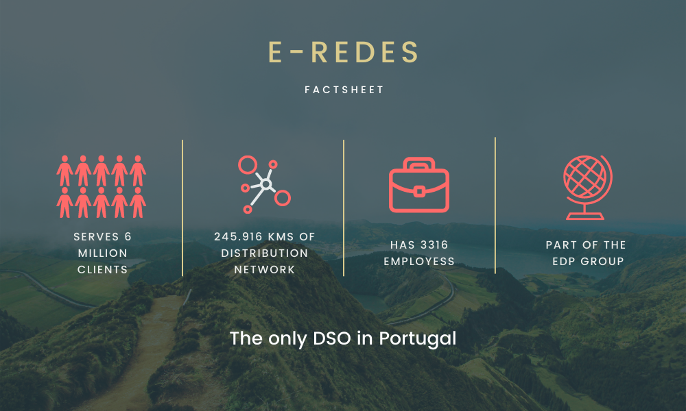
Meet the client: E-REDES

E-REDES (previously named EDP Distribuição) is a Portuguese DSO, which brings electricity to 6 million people and covers all of Portugal through its network. It is a majority private company and also the only DSO in Portugal. E-REDES aims to be the reference European operator in the efficient management of electricity distribution networks, ensuring the provision of a public service of excellence focused on the customer. They promote the development of the distribution network that supports the energy transition and ensures, in an exempt manner, the availability of services to market agents.

E-REDES serves 6 million clients, has 245.916 kms of distribution network, has 3316 employees and is part of the EDP group


The mission

E-REDES has made significant investments in the development of innovative solutions for the management, maintenance, and monitoring of electricity networks, with a special focus on forest areas. They have singled out drone technology as one of the important technological means of inspection of overhead electricity networks in the future.

That is also why E-REDES struck up a partnership with Hepta and created the “GridDrone” project to test the use of drones to complement the current inspections carried out by helicopter. The districts of Coimbra and Viseu were chosen as the test areas, due to their varied and hilly landscape.

Hepta was tasked with collecting power line inspection data in the region, using RGB, LiDAR and infrared imaging. LiDAR was used to calculate the distances between lines and the surrounding vegetation, infrared for detecting overheated elements and RGB to find other defects, such as broken wires. Hepta’s drone operators were tasked to gather 30 to 50 kilometres of LiDAR data and 50 to 70 kilometres of RGB and infrared data per day.

Preparations

As the amount of power line data needed to be gathered and analysed was considerable, Hepta sent three drone teams to Portugal, totalling seven employees and consisting of:

  • four drone pilots
  • one LiDAR specialist
  • one flight planner
  • and one project manager

LiDAR data collection was done by one drone team using a DJI Matrice 300 drone with a YellowScan Mapper LiDAR payload.

Two drone teams conducted RGB and infrared data collection, each using a DJI Mavic 2 Enterprise Dual drone.

Hepta inspection team drone set-up in Coimbra

A high focus was put on flight planning before the start of the project. The landscape in the Coimbra and Viseu districts is quite hilly by nature, frequently resulting in high elevation differences between the towers.

Landscape in the operations area

Collecting 1000 kilometers of power line data

While the task of collecting 1000 kilometres of power line inspection data in a month seemed daunting at first, Hepta’s drone inspection teams were actually able to achieve it faster. A big part of this was thanks to them getting familiar with the grid on-site and surveying the area before the flights. This allowed them to start with a fast tempo from the get-go. While the mountainous terrain offered variable obstacles, from transit times in the area to flight planning and conducting, they were able to achieve and surpass their goals for data collection.

In the end, 1000km of overhead line RGB and infrared photos were collected on 6 lines in just 22 days. This resulted in an average of 55 kilometres of power line data gathered per day.  During those 22 days, the Hepta drone teams took a grand total of 52149 RGB and infrared photos of power lines and towers.

LiDAR mapping 1000 kilometres of power lines and the vegetation surrounding them was achieved in 30 days. On average Hepta’s drone team was able to map 38 kilometres of power lines per day. All of the LiDAR mapping was done with high precision, with 150 points per square meter and 4-6 cm accuracy. All of the LiDAR point clouds were classified, vectorized, analysed, and uploaded to Hepta’s power line inspection platform uBird.


Inspecting 1000 kilometres of power line data

All of the collected data was uploaded and analysed in Hepta’s power line inspection platform uBird. As uBird allows experts to detect and assess issues with much higher accuracy and speed, the inspection process was concluded ahead of schedule.

Each and every one of the 52 149 RGB and infrared photos taken during the data collection phase was uploaded to uBird and analysed by Hepta’s grid analysts. In total, the analysis of RGB and infrared photos took 28 days, averaging 1862 analysed photos per day.

The LiDAR point clouds, that were mapped in the Coimbra and Viseu districts, were over 78 GB in total size. They were classified, vectorised and analysed in the uBird platform. It took a total of 28 days of work to analyse 1000 KM of LiDAR point clouds.

Conclusions and lessons

Taking on a large scale inspection operation always comes with its own set of risks, but thanks to hard work and meticulous preparation, none of them realized. While the transit times in the mountainous regions of Coimbra and Viseu did hinder the operations tempo somewhat and the drone flights there were more challenging, none of it mattered in the end.

Hepta’s operations team managed to gather and analyse 1000 kilometres of power line data ahead of schedule.

You can see the overview of the “GridDrone” project from the E-REDES video below:


Lessons from the project:

  • One factor for this success was the ability to scout, acclimate and get familiar with the surrounding areas ahead of the planned operations. Knowing the lay of the land helped to achieve a fast data gathering tempo from the get-go.
  • It was also great to see both the DJI drones and YellowScan LiDARs work without problems in quite high temperatures. The operations were carried out during summertime and we the operations team did encounter some extremely hot days. But in the end, all of the equipment worked flawlessly and data collection was not affected in any way.
  • During the data collection phase of the project, Hepta’s operations team lived for a month in the test area. They were especially pleased with the support shown by the local residents and officials during that time. From the start of the operations until the end, everyone they came in contact with was warm and helpful. This was greatly valued during the long workdays and left a lasting impression. Obrigado, Portugal!

The amazing views in the project area


Contact us to learn more about digitizing infrastructures and conducting utility inspection with drones and AI

Get in touch