LiDAR and drone inspection of storm damage on overhead powerlines: a pilot project with Suur-Savon Sähkö and ESRI in Finland

The innovative project to detect storm damage brought together by collaboration

Hepta, along with Suur Savon Sähkö (SSS), Järvi Suomen Energia (JSE), and ESRI Finland, conducted a pilot project to prove the feasibility of night-time storm damage detection using drones, LiDAR, and post-flight analysis. The project was called to life to speed up the location and elimination of fallen trees and damage on overhead powerlines during storms. The goal is to shorten electricity outages and improve services for homeowners in Finland’s lake district.

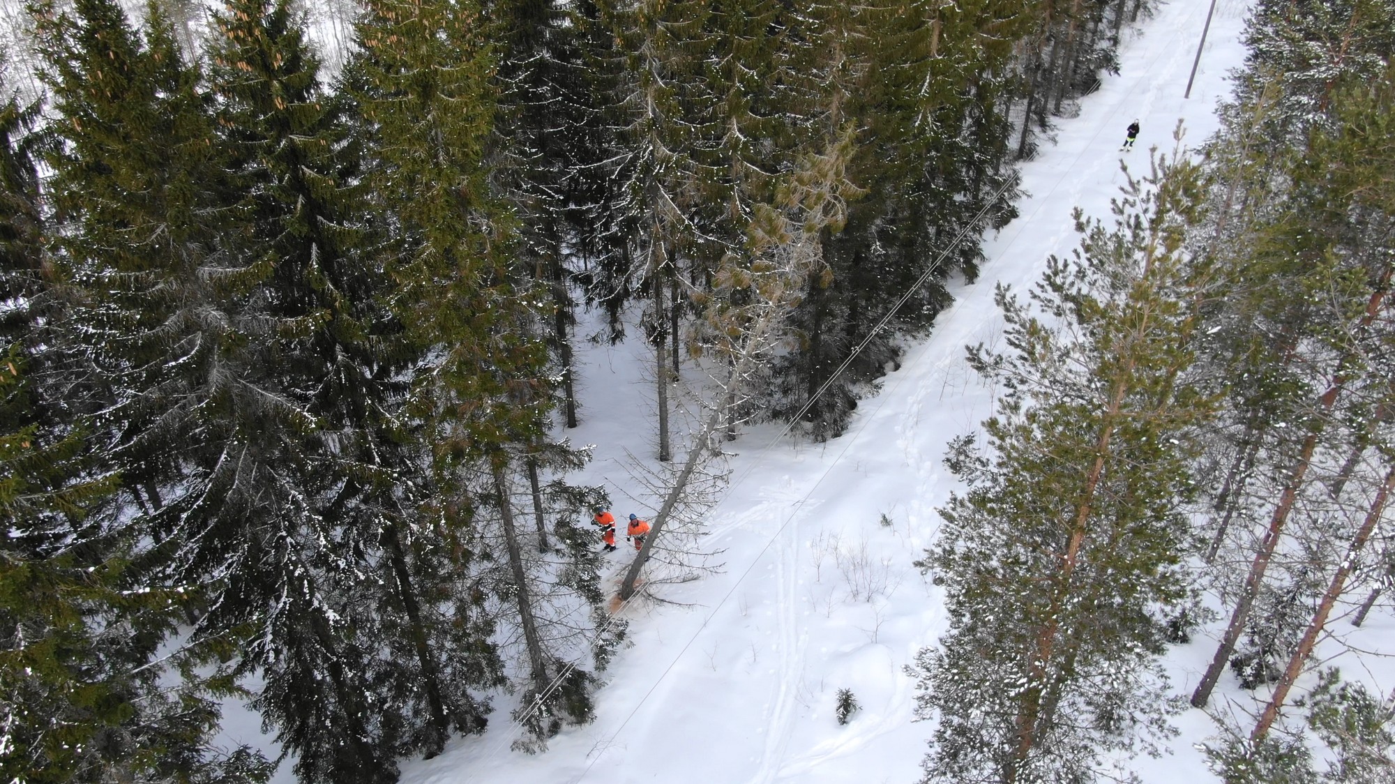
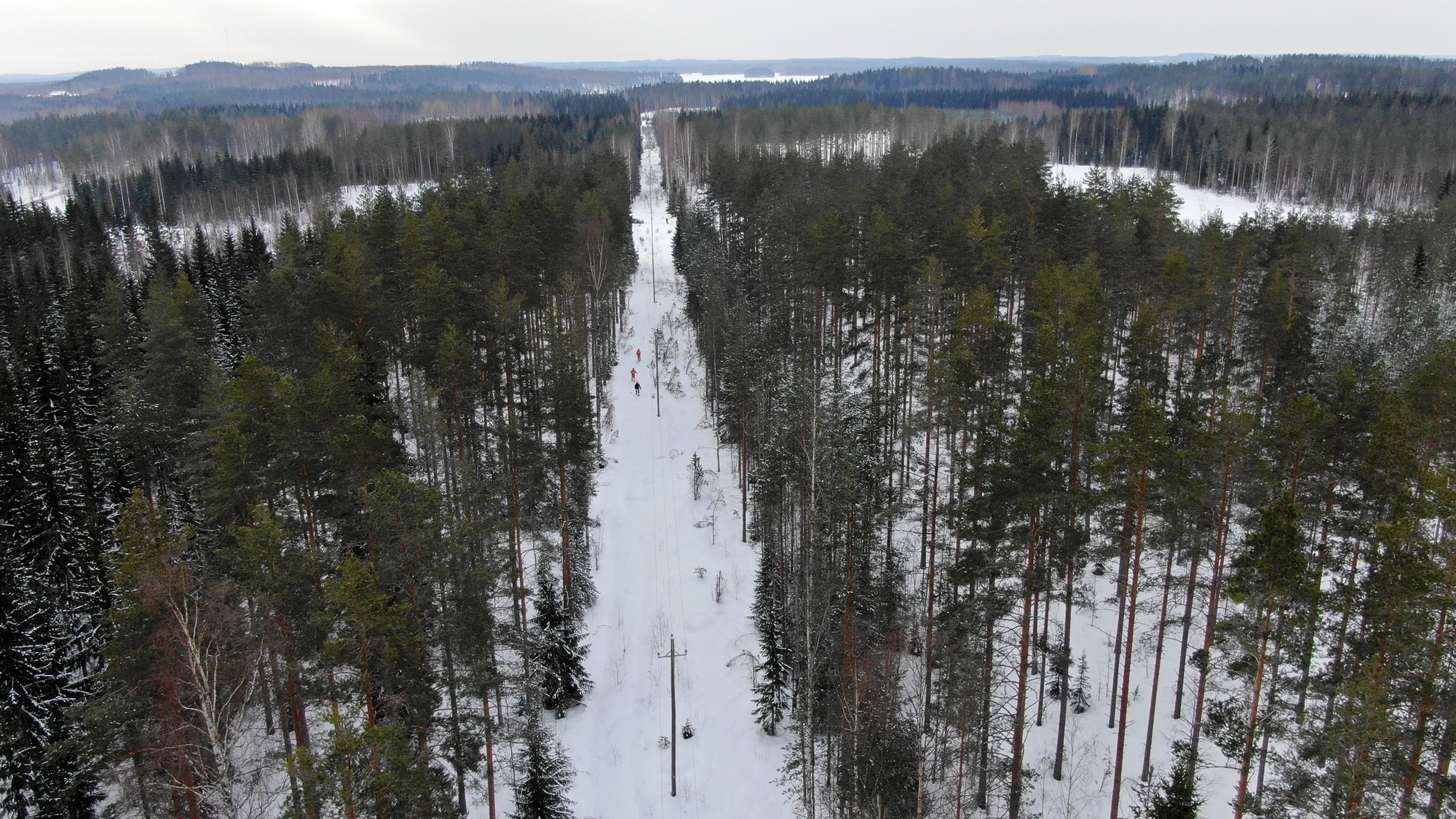
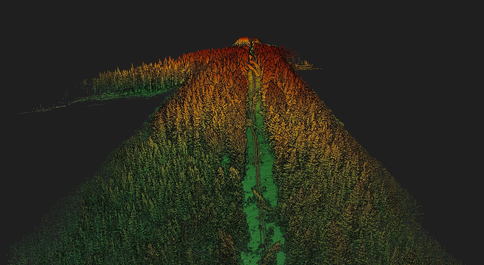
JSE ground team deliberately felling trees on the old overhead power lines. This mimicked possible storm damage which occurs during heavy winds.

The project was brought to life in collaboration between Suur Savon Sähkö, Järvi Suomen Energia, Hepta and ESRI Finland.

Suur-Savon Sähkö (SSS) is an energy group in Finland, and the owner of electricity and heat networks in Finland’s lake district – an area filled with numerous lakes and islands. This location offers unique challenges for managing overhead power line grids. The annual impact of SSS to the regional economy is over 100 million euros.

Järvi Suomen Energia (JSE), a subsidiary of SSS, manages 27,000 kilometers of electricity networks to distribute power to over 100,000 customers. Nearly 50 million euros are invested into developing the electricity networks annually. By continuously developing the network, JSE improves the grid conditions in the region.

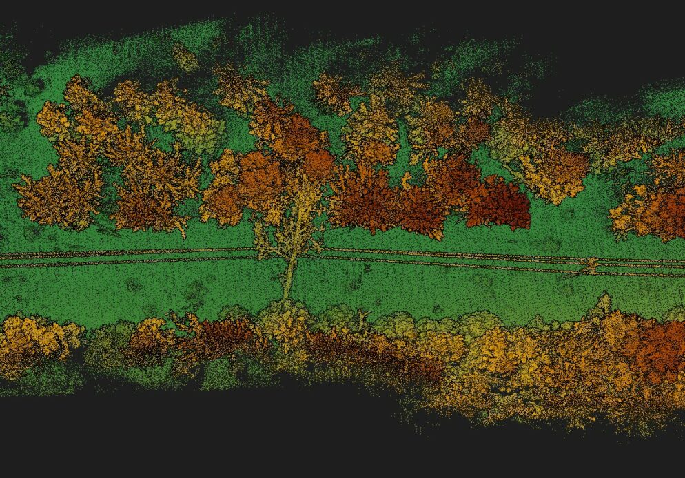
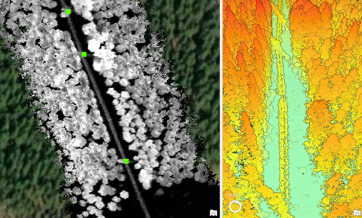
Hepta provides end-to-end automated grid inspection and analysis solutions for overhead power lines in 11 Countries. Starting with drone-based data collection, then analyzing image data with the help of AI in uBird software, and finally delivering the results to the client’s systems.

ESRI Finland offers market-leading GIS solutions to both public organizations and private companies of every size. Their portfolio includes ArcGIS, a solution for damage detection from LiDAR point clouds.

Difficult terrain and limited daylight make finding and eliminating fallen trees on lines a challenge

Cooperation between JSE and Hepta started back in 2020 when the first powerline inspection and analysis project brought beneficial outcomes for both parties. After that, an idea emerged to also use drones to detect fallen trees on power lines during the storm season.

Difficult terrain and low daylight make finding and eliminating fallen trees on lines a challenge

Power outages on middle voltage grids cause thousands of people to lose electricity in their homes during the coldest and darkest time of the year. So it is crucial in the case of a storm and disruption to fly, locate the defects as soon as possible, and eliminate them. During the winter months there is a limited amount of daylight in Finland. This means RGB photos are not always sufficient to detect grid damage. Deep snow and difficult terrain make on-the-ground inspection a tedious and lengthy process – too slow to eliminate outages in a timely manner.
Worldwide, the most prevalent method for DSOs to locate fallen trees on power lines has been walking the stretch of overhead line on foot, skis, or on ATVs. This poses a threat to workers as there may still be falling trees during the storm and an already broken line can electrocute someone. Safety is always the priority, and it especially is important to stress that in such difficult terrain, finding disruptions on foot is extremely time-consuming. When a landscape is rocky, and has many hills and crevices to fall from, an on-ground inspection team progresses slowly and power outages last longer.
To minimize the distance covered on-foot by ground teams and to overcome the limitations of low daylight, Hepta’s team, in collaboration with SSS and JSE, produced a solution to deploy drones to scan overhead lines with LiDAR sensor to detect storm damage. Drones make it possible to cover distances quickly and fly 24/7, while LiDAR sensors can capture data day and night.
An important step was to find a partner to analyze the LiDAR data. ESRI Finland was chosen for its experience and well-known solutions in the geoinformation systems field. This collaboration created an excellent base for the pilot project.
For a quickly growing company like Hepta, this project was unique. It was the first opportunity to attempt detecting damages at night with LiDAR. Traditionally, RGB sensor-utilizing drone inspection is conducted in daylight to capture high-resolution photos, and depends on brightness and a good amount of visible light. So for Hepta, it was also interesting to see if low light operations are possible in scale and to confirm whether fallen trees could be detected with a LiDAR sensor. ESRI wanted to explore whether an algorithm can be built to allow for the instant detection of fallen trees on lines. Suur Savon Sähkö benefits the most from the project in the ability to find solutions that prioritize the speedier elimination of grid faults during storms and to shorten outage times for their customers.
Tomi Öster, the Business Development Manager at Järvi-Suomen Energia commented: “We decided to conduct this project with Hepta because they are experienced and have good maturity in drone inspection. This type of data gathering and analytics is key to benefit from drones on a large scale and put such fast response into operational use. During this project, the most surprising part for me was that the maturity of the solutions our cooperation partners provide is even higher than expected. Hepta’s drone technology and ESRI’s data analytics seem to be a great combination to detect fallen trees in an efficient way. Future plans regarding this inspection method are to get operational benefits next autumn to detect different kinds of disturbances and snow loads during low pressure and thunderstorms.”

Hepta was responsible for booking the airspace for the pilot project dates and flying the drones with LiDAR sensors to collect the raw point cloud data that was used as a reference. After the reference data was collected, JSE brought about the defects by deliberately felling trees on old power lines. This mimicked possible storm damage that occurs during heavy winds. The Hepta team then performed another drone flight and collected the point cloud data for the freshly created defects. For comparison, ESRI analyzed the reference point cloud data and the defect cloud data to provide an automated analysis tool for SSS. As the last step, Hepta performed a third flight on the same line corridor to collect additional data.

Mimicking storm damage from felled trees and gathering the data

There was a unique possibility for this pilot to take place on an old overhead line, which was going to be disassembled. This was the ideal testing ground for the pilot project. In total, 20 trees were deliberately felled on power lines by the JSE ground team. This opportunity was possible because JSE is investing resources to replace overhead lines and install electricity cables underground in the most storm damage-prone areas. Now that the works in that area are completed, the overhead line has become obsolete and needs to be dismantled. Fortunately, the overhead powerline was in excellent condition and was the perfect simulation for Hepta, as it represented the regular conditions for powerline inspection.

First, the project area was determined and Hepta booked the flight permits, then reference data was collected with drones. This means drones with LiDAR sensors mapped the powerlines without any defects – this created a data set to build a 3D point cloud of the overhead line without damages. Then the JSE maintenance team who usually works to get trees off the power line, fell trees on the line. This was a rare and rather unusual work assignment for them, but a crucial part for the pilot project to succeed.

Seeing big trees falling onto powerlines is not an everyday sight so it was interesting, professionally, for all participants to observe and learn. The falling trees caused major damage – lines were broken, some poles were tilted severely at an over 45-degree angle, and some insulators were broken. All of this created a useful setup to perform the second set of drone flights with LiDAR, now over the damaged power line. This needed to gather a second set of point cloud data to compare against the first data set. Several flights with various altitudes (50 and 60 m) and speeds were performed for comparison. This provided input to see what kind of storm damages can be discovered with LiDAR with different methods and what would be the optimal flight parameters. The goal was to conduct the flights as fast as possible without losing any data quality.

LiDAR point cloud image of trees on overhead power lines

In addition, a mapping of the surrounding areas was also done. In the end, SSS has an accurate LiDAR mapped landscape where their infrastructure lays. For comparison, the local land board provides LiDAR images with five points per square meter. Hepta gathers a denser LiDAR point cloud via our drones, starting from 150 to 300 points per square meter. One of the biggest benefits of LiDAR inspection is that it does not require daylight to capture data, which makes it useful in situations with the need to conduct storm inspections even during winter and low-light conditions.

This innovative inspection method can be applied in any country with challenging terrain similar to Finland’s lake district; for example, in neighboring Sweden and Norway. Even more critical than the terrain is the amount of (snow) storms and the frequency of power outages, especially at night. It all comes down to DSOs’ or TSOs’ interest in prioritizing the elimination of outages within the shortest possible time frame. This is only possible by quickly locating the fallen trees and the resulting damage so repair works can start promptly.

"During this project, the most surprising part for me was that the maturity of the solutions our cooperation partners provide is even higher than expected. Hepta's drone technology and ESRI’s data analytics seem to be a great combination to detect fallen trees in an efficient way.” 
Tomi Öster, Business Development Manager at Järvi-Suomen Energia

Technology and outcomes of the storm inspection pilot project

  • The pilot project area was approximately 3 kilometers long and takes 10 to 15 minutes to scan. This meant that it was possible to gather reference data, fell the trees and gather data on the damaged powerline in a single day. A DJI Matrice 600 industrial drone with a YellowScan Surveyor Ultra LiDAR sensor and a DJI Matrice 300 with a YellowScan mapper were used to see whether there was a significant difference between different LiDARs.
  • A’ 20 trees were fallen.
  • A total of 3 km of overhead line and surrounding landscape were mapped with LiDAR sensor. A 3D point cloud comparing the overhead line without damages VS the line with fallen trees and damaged infrastructure was created.

Fallen trees on overhead lines are marked by green squares- outcome of analysing LiDAR point cloud data by ESRI Finland.

ArcGIS software was used by ESRI to compare two data sets. The goal is to develop an algorithm that is able to detect damages and report them pretty much instantly. It will also be beneficial among industries other than DSOs because one of the goals of this project is speed. To collect, upload, and analyze data as fast as possible.

The outcome is an entire power line corridor and defects marked with boxes – for example, if an overhead line is lower than it is supposed to be, broken, or a tree is in on the line, it is marked. A shapefile can be downloaded and transferred to the DSOs system for the maintenance team. The found defects can also be generated and used as a reference when planning repairs. Two views are available, the red error areas on the line map, where the defects are, and the reference to the point cloud itself, with the fallen tree visible.

The next steps for the pilot project of storm damage inspection of power lines with LiDAR will involve Hepta improving the speed of gathering data with drones, and ESRI working on the algorithms to be autonomous and the data processing to be accurate enough to detect the entirety of any damage.

Contact us to learn more about digitizing infrastructures and conducting utility inspection with drones and AI

Get in touch