Power line data analysis
Accurate reports for business and ground teams
- We provide 100% complete analysis for your RGB images, thermal and LiDAR data captured via helicopters, drones, or ground crews
- Trained engineers analyse your data by utilising uBird AI to boost quality, productivity and bring down the cost
- Accurate reports of defects in the web application are downloadable in CSV, Excel and PDF formats
- Integrations with asset management systems such as SAP, NIS, and others get the critical information to relevant parties instantly
- Precise geo-referenced and annotated images give a great overview of the findings for the maintenance teams

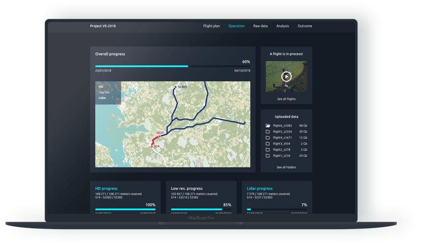
uBird software platform
Turn drone images into analyzed and actionable information
With the uBird software platform, you get a complete and in-depth overview of power lines and defects:
- upload, store and manage all images and point clouds to keep the digital documentation of your grid in one accessible place
- map exact object positions and see the location of photos and the drone on the map
- locate and annotate findings on the photos to form structured reports
- review the outcome on a powerful dashboard
- share actionable reports via the cloud, PDF and XLS formats or integrations with enterprise systems
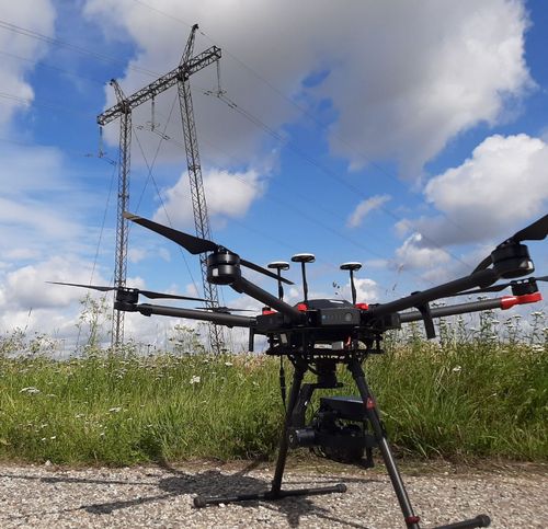
Drone and sensor rental
Rent or buy to inspect any infrastructure
- Lease a variety of drones and sensors with zero risk
- DJI Mavic and Matrice series industrial drones
- Long-range heavy-lifting helicopter drone H19
- Selection of field-proven sensors: RGB, Thermal, LiDAR, Corona
- Get expert help from us with the insurance and BVLOS permits
- Your team gets training from the industry’s top professionals who have a background in aviation and piloting UAVs and extensive experience in inspecting the grid
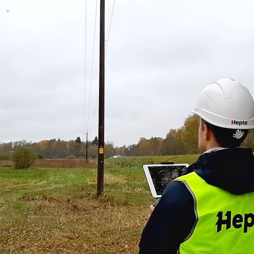
Data capture with drones
Detailed imagery of your infrastructure
- We get BVLOS permits and handle the insurance
- Trained drone pilots plan missions according to your utilities and landscape
- Pilots travel to your location with drones and sensors to conduct the flights and capture the needed data
Full end-to-end inspection service
Seamless data capture, analysis and reporting
You can partner with Hepta to speed up any part of your power line inspection service:
- capturing the data
- analyzing and reporting the data
- using uBird software platform to analyse your own data
- renting the drones and sensors
Also, Hepta can take care of the end-to-end service. We ship the drones and the crew on the site, gather the data, analyse and deliver the results.
Interested in parts of the inspection or full end-to-end power line inspection?
Get in touch
Henri Klemmer
Co-founder & CEO
– Power Engineer, M. Sc
– 12+ years of power line inspection and design
– Founder of a technical design company in the energy sector